
RECYCLING | DRONE STOCKPILE SURVEYS
Turning Stockpiles into Reliable Volume Data
For a major metal recycling operation, understanding how much material was held in loose and baled stockpiles was an important part of inventory assessment. But could drone-derived measurements deliver reliable figures that could withstand independent verification?
Drone-derived measurements were
within 1% of independently validated
results for test stockpiles and bales.
01 / THE PROBLEM
The Challenge
Establish reliable stockpile measurements across metal recycling operations, including loose and baled materials.
02 / THE SOLUTION
Our Approach
Drone-based aerial surveys across three recycling sites, generating nine datasets for processing and measurement.
03 / THE FINDING
The Evidence
Drone-derived measurements compared against independently validated test stockpiles and bales.
04 / THE VALUE
Why It Matters
Validated measurement data can support stock assessments, inventory planning and more informed operational decisions.
UNDERSTANDING THE CHALLENGE
When Stockpile Figures Need to Stand Up to Scrutiny
For a metal recycling operation, knowing how much material is held in stockpiles is an important part of understanding inventory and supporting business decisions. However, irregular piles of loose and baled metal can present measurement challenges.
The requirement was to establish whether drone-based surveying could generate reliable measurements across different stockpile types and recycling sites. Capturing aerial data was only one part of the challenge. The resulting measurements also needed to be checked against independently established quantities.
The project therefore needed to demonstrate more than the ability to produce a 3D model. It needed to establish whether the information could be used with confidence as part of stock assessment and inventory review.
WHAT THE CLIENT NEEDED TO KNOW
Three Questions That Mattered
Could different stockpiles be measured consistently?
Assess the suitability of aerial survey data for loose and baled metal across multiple sites.
How dependable were the calculated quantities?
Compare drone-derived measurements with independently established test quantities.
Could the findings support inventory decisions?
Establish whether the measurement approach could provide useful evidence for operational review.
The real test was not whether a drone could survey the site. It was whether the resulting measurements could be independently validated.
From Complex Stockpiles to Verifiable Measurements
The starting point was not simply deciding which drone to fly. Iprosurv needed to establish a survey and processing approach capable of measuring different types of stockpiled metal across working recycling sites.
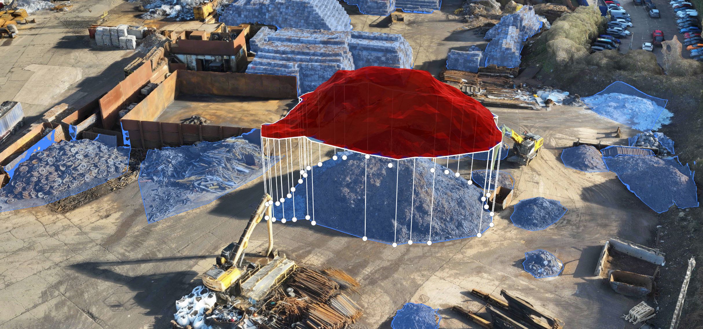
By combining aerial data capture with photogrammetric processing, the project could produce digital representations of the stockpiles from which volumes could be calculated and reviewed.
Crucially, the approach also incorporated independent checks against established test quantities. This meant the survey results could be evaluated against external measurements rather than relying on the digital models alone.
01 / SURVEY STRATEGY
Account for Different Materials
Consider the different forms and profiles of loose and baled metal so that the survey approach could be evaluated across representative stockpiles.
02 / DIGITAL MEASUREMENT
Turn Imagery into Volume Data
Process aerial survey imagery into measurable digital surfaces, providing a basis for calculating and reviewing stockpile volumes.
03 / INDEPENDENT VERIFICATION
Test the Findings
Compare the drone-derived calculations with independently established reference quantities to assess the reliability of the measurement process.
The objective was not simply to create a 3D model of a recycling site. It was to establish whether drone-derived measurement data could provide a dependable basis for stock assessment and operational decision-making.
From Aerial Survey to Measurable Stockpile Data
Iprosurv undertook a structured proof-of-concept programme across three recycling sites, combining repeat aerial surveys, digital processing and independent checks to assess the reliability of stockpile measurements.
Capture the Site Data
Following site risk assessments and the establishment of safe take-off and landing areas, Iprosurv used the DJI Mavic 3E to capture aerial survey data. Each of the three recycling sites was surveyed three times, producing nine datasets.
Process and Measure
The aerial data was processed using gNext Labs software to generate digital stockpile models, calculate volumes and produce measurement reports for loose and baled metal.
Validate the Measurements
Test stockpiles and bales were independently measured and weighed. These reference quantities were compared with the drone-derived findings to evaluate measurement performance.
STOCKPILE VOLUME MODELLING
Illustrative stockpile measurement visualisation. Digital surface models allow stockpile volumes to be calculated and reviewed.
9 datasets
Across 3 sites
THE PROJECT OUTCOME
Reliable Measurements. Independently Tested.
The proof-of-concept surveys demonstrated that drone-derived stockpile measurements could be checked against independently established reference quantities.
For the selected validation stockpiles and bales, the calculated results were within 1% of the independently established quantities. This provided encouraging evidence of the measurement approach's suitability for the materials and conditions tested.
The real value was confidence
in the information.
By testing digital measurements against independent reference quantities, the client could assess whether drone surveying offered a practical method for supporting stock assessments, inventory reviews and future operational planning.
INDEPENDENTLY VALIDATED RESULT
Within 1%
Of Reference Quantities
Drone-derived results for the selected test stockpiles and bales were within 1% of independently established quantities.
WHAT THE CLIENT RECEIVED
Volume Data That Could Be Checked, Not Just Viewed
The project moved beyond capturing aerial imagery of recycling sites. It produced digital representations of the stockpiles, calculated volumes and findings that could be compared with independent reference quantities.
For the client, this provided measurable evidence of how drone-based surveying performed across the materials and conditions assessed during the project.
These findings could help inform whether the approach was suitable for future stock assessments, inventory reviews and operational planning.
THE EVIDENCE
Digital Stockpile Models
Processed aerial survey information representing loose and baled metal stockpiles, allowing their shapes and profiles to be reviewed.
Calculated Stockpile Volumes
Quantified volume measurements derived from the survey data, providing figures that could support stock assessment and inventory review.
Independent Validation Evidence
A comparison of selected drone-derived results against independently established reference quantities, demonstrating measurement performance during the proof-of-concept programme.
YOUR CHALLENGE. OUR EXPERIENCE.
Have a Challenge of Your Own?
Whether you need accurate stockpile measurements, a better understanding of your inventory or reliable data to support operational decisions, the starting point is understanding what you need to achieve.
Talk to Iprosurv
Explore More Case Studies
Start with your challenge. We'll explore the solution together.