Woodland Surveys
Placeholder content: replace with information about this sector. Iprosurv helps organisations in Forestry with woodland…
Fallen timber, blocked access routes and
unstable trees can make assessing storm
damage a challenging and potentially
dangerous task.
Drone technology provides a different
perspective, helping forestry professionals
see the extent of the damage, understand
the landscape and plan what happens next.
Severe storms can damage hundreds of
hectares of managed woodland, leaving
forestry teams with difficult decisions
about access, safety, recovery and
future management.
The challenge is not simply identifying
fallen trees. It is understanding where
the damage has occurred, how extensive
it is and which areas require further
investigation.
Drone surveys provide a rapid aerial
overview of visible conditions, helping
organisations target their ground
assessments and avoid unnecessary
entry into hazardous areas.
Identify affected woodland compartments
and concentrations of windblown timber.
Use mapped imagery to establish
approximate areas of visible damage.
Identify obstructed tracks and
potential access constraints.
Provide visual records to landowners,
contractors, insurers and advisers.
Drones are more than flying cameras.
With appropriate survey planning and
processing, aerial imagery becomes
useful information for assessing
damage and supporting recovery.
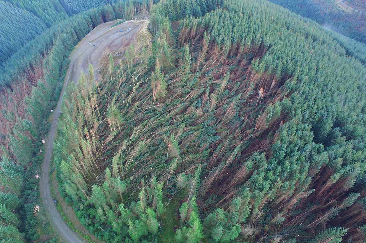
Aerial imagery can reveal patterns of
windthrow, damaged stands and fallen
trees that may be difficult to recognise
from ground level.
Overlapping aerial photographs can
be processed into orthomosaic maps.
These provide a georeferenced overview
to help locate, outline and measure
visibly affected areas.
Survey information helps forestry
managers identify access constraints,
prioritise detailed inspections and
coordinate contractors before
recovery operations begin.
Aerial photography, mapped information
and digital models can provide a
valuable record for landowners,
forestry managers and insurance
assessments.
Capturing aerial images is one part of
the process. Processing those images
into useful, shareable information is
what allows forestry teams to make
better-informed decisions.
High-resolution imagery provides
an initial visual understanding of
site conditions and damage.
Images are combined into a
georeferenced map, allowing visible
damage to be located and measured.
Where appropriate, 3D models,
terrain data or LiDAR datasets
provide further spatial information
for planning and analysis.
Following Storm Arwen in November 2021,
Iprosurv was deployed to support the
assessment of extensive windblown
forestry.
The project involved aerial surveying,
high-resolution image capture and
processing into digital mapping
deliverables, helping the client
understand the affected area and
begin planning recovery operations.
Figures relate to this specific
Iprosurv project. Survey durations
and deliverables vary according
to site conditions and requirements.
Iprosurv forestry storm-damage assessment
following Storm Arwen.
Aerial inspection can reduce the
need for personnel to enter unstable
woodland simply to establish an
initial overview.
Mapped imagery provides spatial
context across the surveyed area,
helping teams identify where further
investigation is required.
Share suitable survey outputs with
forestry managers, contractors,
landowners and insurers to support
coordinated decisions.
No two storm-damage events are
identical, and neither are the
survey requirements.
Iprosurv combines professional
drone operations with expertise
in photogrammetry, aerial mapping
and digital data processing.
From initial visual assessments
to detailed orthomosaic mapping
and advanced survey deliverables,
we help establish an appropriate
approach based on your objectives,
site conditions and intended use
of the information.
We can also help organisations
develop their own internal drone
capabilities through professional
training, equipment supply and
operational consultancy.
Photographic records of visible
storm damage and site conditions.
Georeferenced imagery suitable
for review and spatial analysis.
Additional digital outputs
where equipment, conditions
and survey requirements permit.
Guidance on suitable survey
methods, training, software
and equipment.
Talk to Iprosurv
Whether you need an experienced drone
survey team, want to introduce drones
into your own operations or need
guidance on the right technology,
our team is here to help.
Whatever you need drones to do, there are three ways to work with Iprosurv.
Our pilots carry out the survey or inspection and deliver the data and reports you need.
Accredited courses that give you and your team the skills to fly safely and legally.
The drones, sensors and software to run your own operations, with expert advice.
Tell us what you are trying to achieve and we will recommend the right service, training or equipment.