
Unparalleled Data Collection
In the realm of engineering, the utilization of drones has revolutionized various facets, ranging from statutory inspections to expansive infrastructure projects. Drones, equipped with advanced imaging and data-capturing technologies, have become indispensable tools for engineers and project managers.
These aerial devices offer a bird’s-eye view, enabling efficient and thorough inspections of structures, pipelines, and installations. Beyond mere visual assessments, drones provide a wealth of accurate, data-driven insights.
By collecting precise measurements and high-resolution imagery, they empower decision-makers with comprehensive information, facilitating informed choices in project planning, execution, and maintenance.
This not only enhances the efficiency of engineering operations but also ensures the safety and longevity of critical infrastructure. Moreover, the ability of drones to deliver real-time, detailed data fosters transparent communication and engagement with stakeholders, fostering collaboration and trust within the engineering community.
Transforming Engineering Inspections
Drones are revolutionizing statutory inspections, particularly in the context of LOLER inspections for structures like gantry cranes and lift shafts.
These unmanned aerial vehicles offer a game-changing solution to address health and safety concerns in various challenging environments. In confined spaces such as culverts and reduced access sites, drones equipped with Lidar scans prove invaluable by providing extremely accurate sub-centimeter results.
This data can be seamlessly integrated into CAD, BIM modelling software, and GIS software, streamlining the inspection process and enhancing the precision of assessments. Moreover, in high-risk areas like contaminated sites, including digestors and nuclear facilities, drones like the M350, armed with multiple sensors such as Lidar, Gas, Air quality sensors, and high-end thermal cameras, play a crucial role in minimizing human exposure to potential hazards.
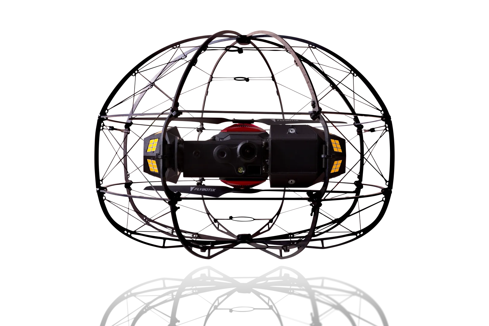
Tailored drones like the Flybotix Asio X, designed for confined inspections, further enhance safety measures with specialized sensors, including thermal and Gas sensing technology.
Overall, the utilization of drones in statutory inspections not only improves efficiency but significantly contributes to mitigating health and safety risks in diverse and challenging environments.
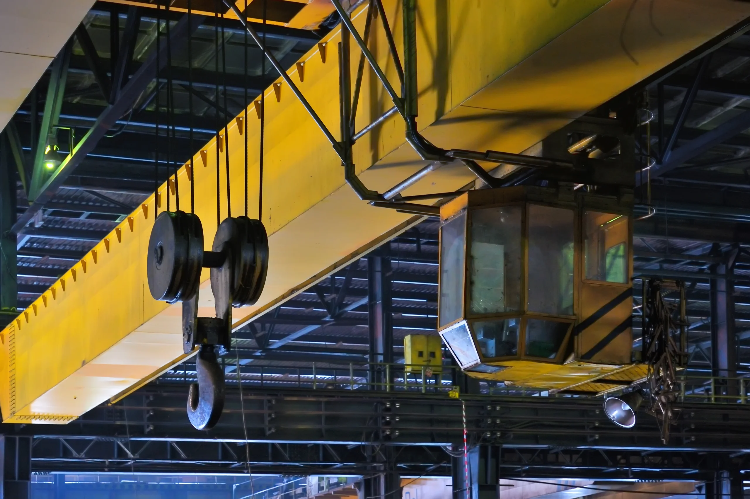
Statutory LOLER Inspections
In the evolution of LOLER inspections, a cutting-edge approach involves seamlessly integrating physical assessments with automated drone inspections, presenting a synergistic inspection regime.
Traditionally, the meticulous nature of physical inspections demanded considerable time and resources. However, by strategically incorporating automated drone inspections into the process, the entire evaluation becomes a streamlined and resource-efficient operation.
After the initial physical inspection lays the groundwork, drones take flight to scrutinize equipment from vantage points otherwise inaccessible, providing an in-depth analysis of structural integrity and potential issues. This fusion of traditional and modern inspection methodologies not only enhances the thoroughness of the evaluation but also significantly reduces the overall time, downtime, and costs for clients.
The efficiency of automated drone inspections not only minimizes human exposure to potential risks but also ensures a more accurate and expedited compliance process, marking a transformative shift in the landscape of LOLER inspections.
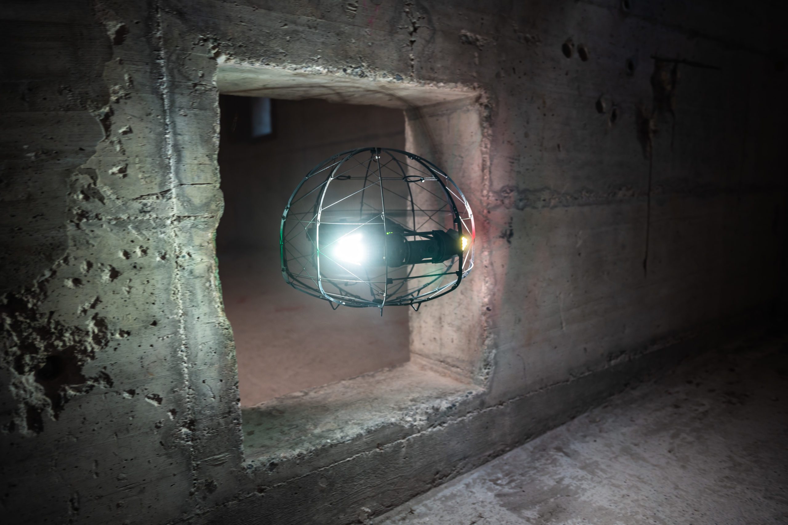
Confined, Hard to Reach and Contaminated Spaces
Drones offer a myriad of advantages when employed in confined, reduced access, and contaminated sites, revolutionizing the way we navigate and assess challenging environments.
Firstly, their compact size and agile manoeuvrability enable them to access tight spaces and complex structures, providing a comprehensive visual inspection without risking human safety.
Additionally, drones equipped with advanced sensors and imaging technology can swiftly collect data, allowing for real-time monitoring and analysis of contaminated areas. This not only enhances the efficiency of environmental assessments but also minimizes human exposure to hazardous substances.
Drones also contribute to cost-effectiveness by reducing the need for extensive physical infrastructure and manual labor in inaccessible locations. Furthermore, their ability to cover large areas quickly ensures swift response times in emergency situations, aiding in disaster management and recovery efforts.
Overall, the utilization of drones in confined and contaminated sites presents a powerful solution for enhancing safety, efficiency, and accuracy in various industries, from environmental monitoring to infrastructure inspection.
Real Time Data Collection
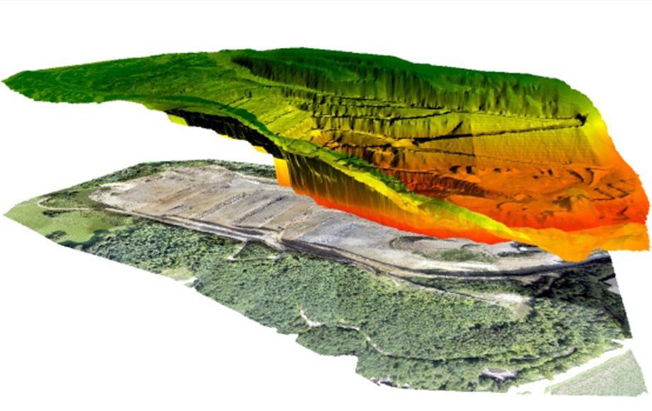
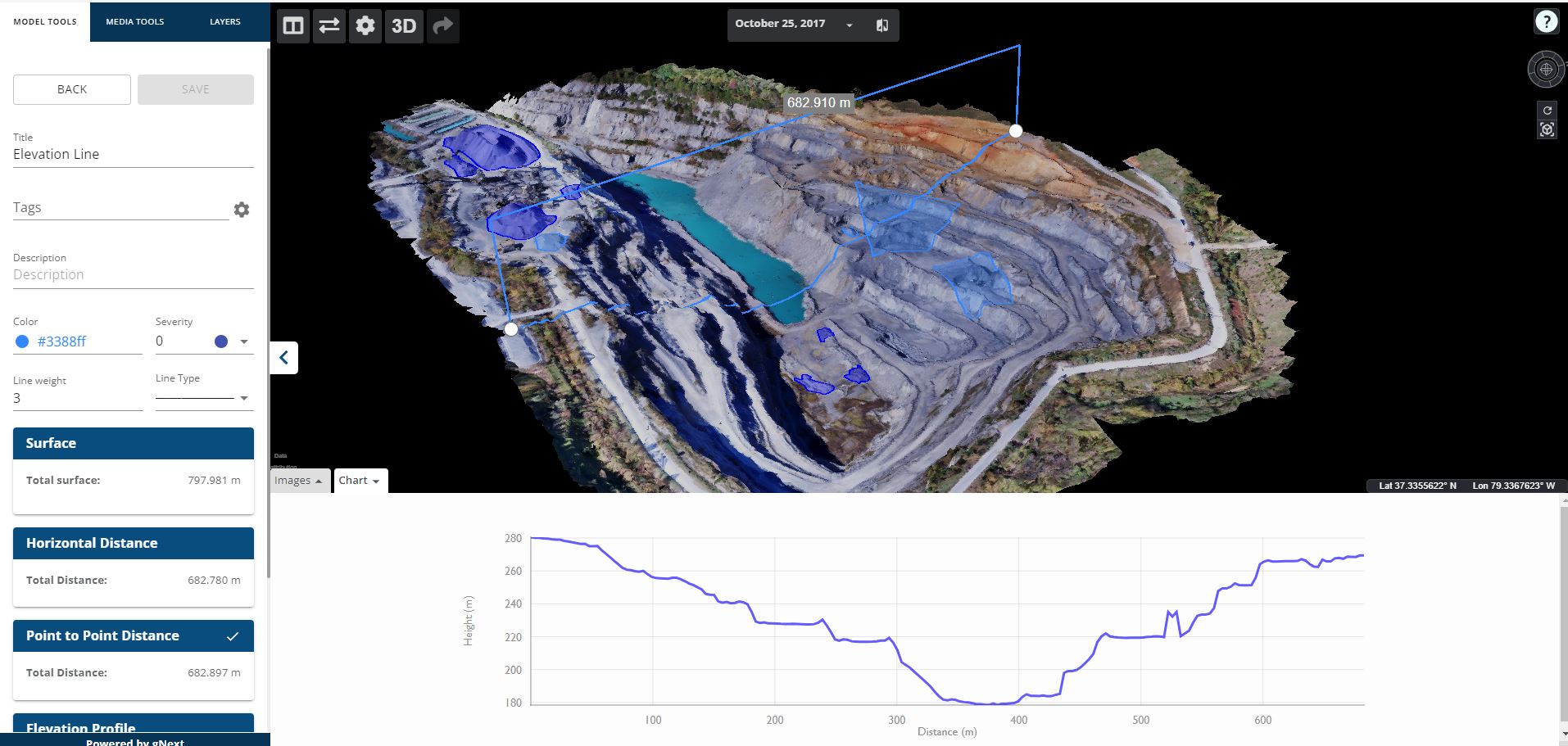
The utilization of drones has revolutionized various industries by providing unparalleled advantages in real-time data capture and precision through Light Detection and Ranging (LiDAR) technology.
Drones equipped with LiDAR sensors can swiftly and accurately collect three-dimensional spatial information, allowing for detailed and precise mapping of terrain, infrastructure, and environmental features.
Drones contribute to the efficiency of data collection by offering the capability to fly automated missions, ensuring a simple and repeatable dataset gathered consistently over time.
Through automated mapping missions, drones follow predetermined flight paths with precision, guaranteeing that data is collected in the same manner on each occasion. This repeatability not only enhances the accuracy of information but also allows for easy monitoring of changes over time.
By integrating specific software applications, users can generate historical datasets that provide valuable insights into project progress and development. This historical perspective facilitates trend analysis, enabling stakeholders to track changes, identify patterns, and make informed decisions based on a comprehensive understanding of the evolving landscape.
The combination of automated drone flights and advanced software solutions thus not only ensures data accuracy but also empowers users to create a valuable repository of project history for enhanced decision-making processes, fostering improved planning, analysis, and collaboration across various sectors.