Get a quote

Drones Aid Recovery After Devastating Village Fire

Utilising drone technology after a major loss event can ensure your clients get the answers and decisions they need, at a time when they need you most. Read our Wennington fire case study.

Drones Assist After Village Fire

Drones Aid Recovery After Devastating Village Fire

Overview

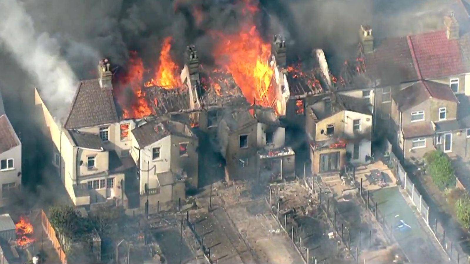
On 19 July 2022, Wennington Village in East London was struck by a devastating fire during a period of record-breaking temperatures across Europe.

The fire, which reportedly started from a compost heap, quickly escalated into a major blaze that involved multiple properties and adjacent grasslands.

Over 100 firefighters were deployed to manage the inferno that ultimately led to the destruction of 19 homes and significant damage to several others.

The severity of the situation prompted authorities to declare a major incident.

Wennington Fire

Challenges

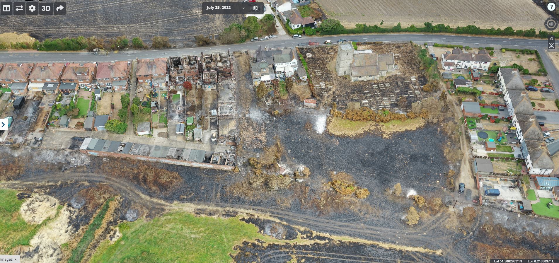
The aftermath of the fire posed significant challenges for recovery and assessment efforts. Many buildings were left in a precarious state, with risks of collapse making it nearly impossible to conduct traditional on-site surveys for insurance loss purposes.

Additionally, access to the village was heavily restricted due to ongoing post-incident operations, complicating efforts for loss adjusters, insurers, and residents attempting to assess damages and coordinate rebuilding efforts.

Unlocking Aerial Expertise- iProsurvs Corporate 10-Day Advanced Drone Pilot Course

Implementation of Drone Technology

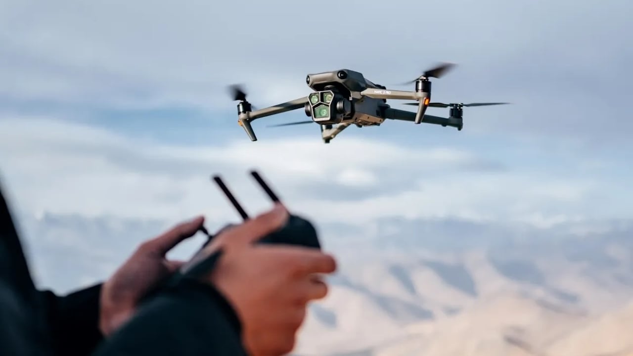
In response to these challenges, drone technology was utilised to facilitate rapid and safe assessment of the damages.

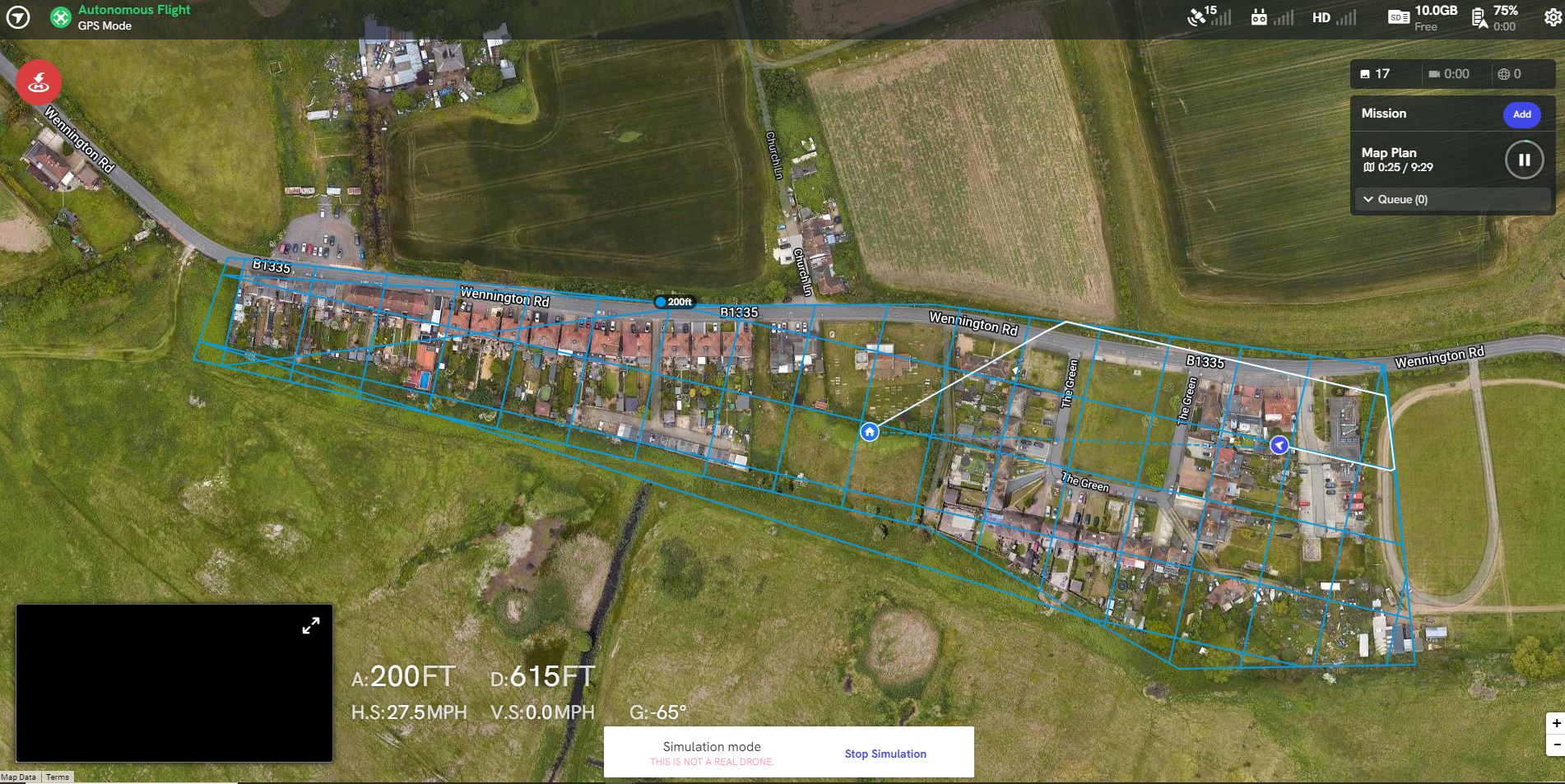
Drones equipped with advanced imaging and sensing technology were deployed to perform semi-autonomous flights over the affected area.

This allowed for comprehensive data collection from various angles without the need for physical entry into hazardous zones.

Revolutionizing High-Rise Cladding Inspections-The Strategic Implementation of Drone Technology for Enhanced Building Safety

Advantages of Drones

  • Safety: The use of drones significantly minimised health and safety risks by eliminating the need for physical access to unstable structures.
  • Efficiency: Drones provided a quick means of assessing damage, crucial for accelerating the insurance claims process and allowing residents to initiate their recovery efforts.
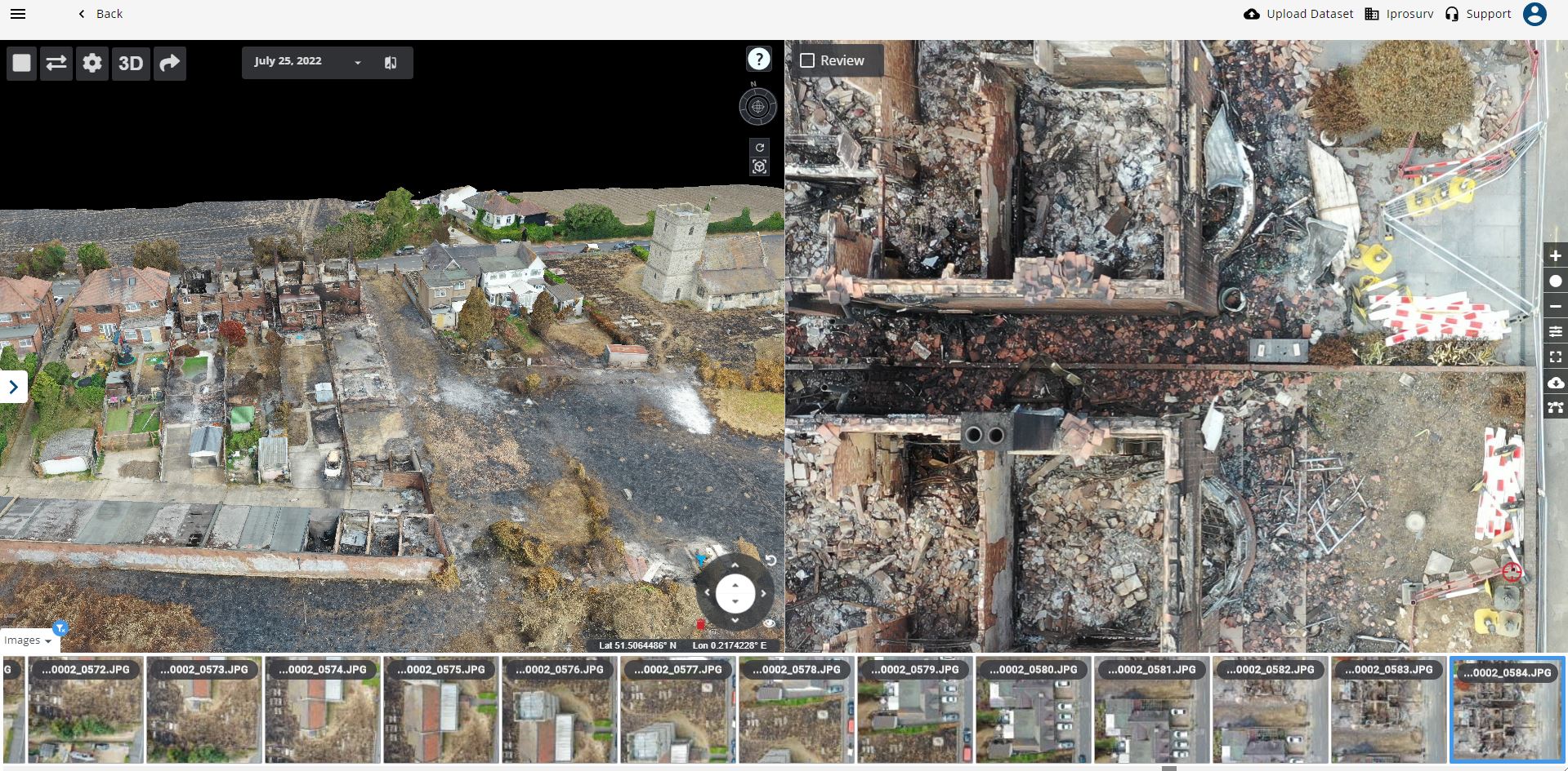
  • Comprehensive Data Collection: The drones captured high-resolution images and videos, which were then processed using specialist software to create interactive 3D models of the affected properties.
  • Data Sharing: The data collected was not only useful for immediate assessments but also served as a permanent record that could be accessed by multiple stakeholders including structural engineers, forensic experts, and fire investigators. This facilitated coordinated planning for access, scope of works, and further investigations.
  • Long-term Monitoring: The archived drone data could be referenced for ongoing monitoring of the reconstruction efforts and revisited for any claims clarification or additional assessments.
Automated Planning Flight Wennington

Software Outputs and Enhanced Data Utilization

Following the deployment of drone technology in the assessment of the Wennington fire damage, the capabilities of the pilot, enhanced through additional training from Iprosurv, played a pivotal role in maximizing the utility of the collected data.

This training equipped the pilot with the skills necessary to optimize flight plans and data capture techniques, which were crucial for generating multiple useful outputs from a single data collection session.

3D Model Output Wennington

Data Processing and Outputs

The data gathered by the drone was processed to produce a variety of detailed outputs, crucial for different aspects of the post-fire analysis and recovery efforts:

  1. 3D Interactive Models: These models provided a dynamic and comprehensive view of the damage, allowing stakeholders to “walk through” the site virtually to inspect damage from multiple perspectives.
  2. 2D Ortho Mosaics: High-resolution aerial views stitched together from numerous drone images offered a precise, bird’s-eye view of the entire affected area, useful for mapping and broad-scale assessments.
  3. Land Elevations: Elevation data helped in understanding the topography changes caused by the fire, which was important for planning reconstruction and mitigating future fire risks.
Gold Command

Enhanced Decision Making

The variety of outputs from the drone data was instrumental in facilitating better decision-making.

By having access to detailed, accurate visualisations and measurements, stakeholders could make more informed choices about resource allocation, planning reconstruction, and prioritising areas in need of urgent intervention.

The ability to generate multiple data types from a single flight not only saved time and resources but also provided a holistic view of the impact, enhancing the efficiency and effectiveness of the recovery process.


These advanced software outputs, enabled by the skilled operation of the drone, highlighted the critical role of specialized training and technology in managing complex disaster recovery scenarios.

This approach not only ensured safety and speed in the initial assessment phases but also supported longer-term planning and rebuilding efforts with a rich dataset that could be revisited as needed.

Impact

Impact

The deployment of drones proved instrumental in managing the Wennington fire incident’s aftermath. The technology provided a critical tool for quickly gathering detailed information under conditions that would have otherwise delayed recovery processes.

The ability to share the collected data among various stakeholders ensured that all parties involved had access to accurate and detailed information, aiding in efficient decision-making and planning.

Ultimately, drone technology not only enhanced safety and operational efficiency but also played a vital role in helping the community of Wennington navigate the challenges of disaster recovery.

Equipment, Software and Training For this Application

Summary

On July 19, 2022, Wennington Village in East London was severely impacted by a large fire during a period of record-breaking heat across Europe. The fire, starting from a compost heap, escalated rapidly, destroying 19 homes and damaging several others. Over 100 firefighters battled the blaze, and the extent of the damage led to the declaration of a major incident.

In the aftermath, the traditional methods of damage assessment were impractical due to the instability of structures and restricted access to the affected area. To address these challenges, drone technology was deployed, utilising advanced imaging and sensing capabilities. Drones conducted semi-autonomous flights over the village, collecting comprehensive data without the need for physical entry into dangerous zones.

The data captured by drones was processed into multiple outputs, including 3D interactive models, 2D orthomosaics, and land elevations, facilitated by the pilot’s specialized training from Iprosurv. These outputs were crucial in enabling detailed assessments of the damage and facilitated efficient, informed decision-making for recovery and rebuilding efforts.

This case study illustrates the essential role of drone technology in disaster management, particularly in scenarios where traditional assessment methods are hindered by safety risks and accessibility issues. The use of drones not only enhanced safety but also expedited the recovery process by providing detailed, actionable data to stakeholders, demonstrating a progressive approach to emergency response and disaster recovery.

Conclusion: Embracing Advanced Technologies for Effective Disaster Management

The Wennington fire incident of July 19, 2022, exemplifies a transformative approach in disaster management, where the integration of advanced drone technology and specialised pilot training dramatically improved the efficiency and safety of post-disaster assessments. This case study not only underscores the critical need for incorporating technology in emergency response strategies, but also highlights the tangible benefits of doing so.

Drones, equipped with cutting-edge imaging technologies, provided a means to quickly and safely assess the extent of damage without the risks associated with physical site entry. The comprehensive data captured—transformed into various analytical outputs like 3D models and Ortho-mosaics— served as invaluable tools for loss adjusters, insurers, and recovery teams, facilitating a faster and more informed decision-making process. This approach minimised delays in recovery efforts, enabling a quicker return to normalcy for the affected residents.

Furthermore, the case of Wennington illuminates the importance of continuous improvement in the skills and tools we rely upon in disaster management. The additional training received from Iprosurv empowered the drone pilot to maximise the potential of the technology, demonstrating that the intersection of training and technology can elevate disaster response capabilities to new heights.

As we move forward, this incident serves as a compelling argument for broader adoption and investment in similar technologies across various sectors vulnerable to disasters. It calls for a proactive stance in disaster preparedness, advocating for the integration of technology not just as a supplementary tool, but as a fundamental component of disaster response and recovery frameworks. By doing so, communities are not only better equipped to handle emergencies but are also positioned to rebuild more swiftly and effectively, ensuring resilience in the face of future adversities.

Book A Consultation

FAQ

Are you able to do 3D modeling and automated flight with all drones?

You can 3D/2D model and make ortho-mosaic models with virtualy any drone with a camera, howvere the difference is how long and hiow accurate the data will be.

In order to create a good model or map you need to calcualte such things as image overlap, ground sample distance (GSD) and much more, the more accurate you want the moel or map to be the better the data collection has to be.

Hobbyist drones such as the Mavic Mini 4 will need 3rd party software to plan the correct data collection, DJI Enterprise drones that come with DJI Pilot 2 have in built mapping software that takes a lot of the headache out of the data collection.

Booking on a good mapping and photogrammetry course such as Iprosurv’s 2 Mapping and Photogrammetry course is ideal to start you mapping.

Are there different drones for mapping?

As we always say here at Iprosurv not one drone fits all, dont expect to buy the most expensive drone and it be fantastic at every application, a cheaper drone could produce better results.

If you need help choosing your drone get intouch with us and we will advise you on the correct drone for the job and expected outputs.

Can I buy a package of drone software and training?

Yes you can, we will package rpoducts together for you and often apply a discount if you are training through us, contact us to find out more.