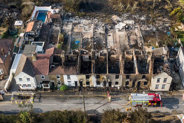
Fire! When your client needs you most!
When a major event occurs weather that be fire or flood the effects can be devastating, not only for the affected property or properties and business but for the people affected by the event. Fire and flood can have major implications on persons lives whether that be financial or physical and mental health.
In these scenarios the people affected rely on professionals such as Loss adjusters, insurance companies, engineers and contractors to facilitate quick decision making and solutions. One of the problems is the accessibility of the affected area due to access issues or safety. By incorporating Drone technology led fire damage and major loss inspections into your workflow could pay dividends.
After a major fire event in the south of England which affected a large retail outlet, Iprosurv were contacted by one of our clients to facilitate the collection of data to enable the decision making process to be started, reserves had to be set and works needed to commence in order for decisions and further actions to be planned. The issue encountered was that the structure had been so badly damaged due to fire that large parts of the structure had collapsed and access due to safety was restricted, the emergency services were also still on site dealing with the incident.

Traditional Methods
The traditional way of dealing with these types of scenarios would be multiple people attending site to carry out their own investigations, compiling reports and presenting the data to the major stakeholder or client. In the case in question the structure could not be accessed and any access around the structure was very limited.
Technology Led Methods
With the continued growth of drone technology and the huge leaps in the advancement of drones and the sensors attached to them data gathering and advanced data outputs can be carried out in a very quick time. Not only can the data be delivered in multiple formats often drone technology will give the professional a unique view that would normally could only be obtained by expensive and time consuming methods. The data set can be delivered and viewed by multiple people offsite or from desktop. Not only does this save time and money as well as increasing safety there is also the reduction in carbon output due to limiting unnecessary visits.
Summary
“Drones are proving to be a valuable tool for assessing fire damaged properties.
They can quickly and safely capture detailed data from difficult-to-reach areas, such as the inside of buildings. This data can be used to assess the extent of the damage, identify any hazards, and plan for repairs or demolition.
The ability to revisit one data set after demolition is also a valuable asset. This allows for a more accurate assessment of the damage and can help to identify any hidden hazards. Drones are a powerful tool that can help to make the rebuilding process after a fire more efficient and safe.”
Here are some additional points that could be included in the closing paragraph:
- Drones can be used to assess fire damage in real time, which can help firefighters to make decisions about how to best fight the fire.
- Drones can be used to create 3D models of fire damaged properties, which can be used to plan repairs or demolition.
- Drones can be used to survey fire damaged areas for hazards, such as downed power lines or leaking gas lines.
- Drones can be used to document fire damage for insurance purposes.
Overall, drones are a valuable tool that can help to improve the response to fire damage and the rebuilding process.


