
Overview
Illegal fly-tipping, a persistent problem across many rural and urban areas, has seen increased incidents over recent years.
This case study focuses on a collaborative project between Iprosurv and a client in the South of England, aiming to tackle the issue using drones for data collection.
The primary goal was to assess the scale of illegal fly-tipping over a given period, effectively monitor known problem areas, and collect reliable data for potential prosecutions.
Drones were deployed to cover large areas, delivering real-time data that could be processed and analysed using specialised software to map out fly-tipping hotspots, reduce on-site risks, and provide evidence that could support legal action against offenders.
Challanges
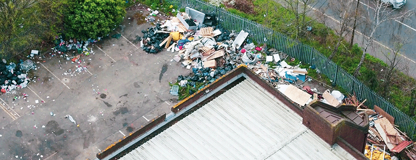
- Large Areas to Cover: The South of England’s landscape included vast rural lands and difficult-to-reach areas, which posed a challenge in monitoring fly-tipping locations efficiently.
- Health and Safety Risks: Inspectors faced hazards when collecting data in areas containing harmful waste such as asbestos. There was also the risk of hostile confrontations with individuals involved in illegal fly-tipping.
- Data Accuracy: Manual inspections for measuring the extent of fly-tipping were often imprecise and time-consuming, lacking the accuracy needed for legal proceedings and thorough analysis over time.
- Historical Data: Understanding the growth of the issue required historical datasets and evidence that could be integrated with new drone-gathered data to assess trends and create comprehensive strategies for combating fly-tipping.
Implementation of Drone Technology
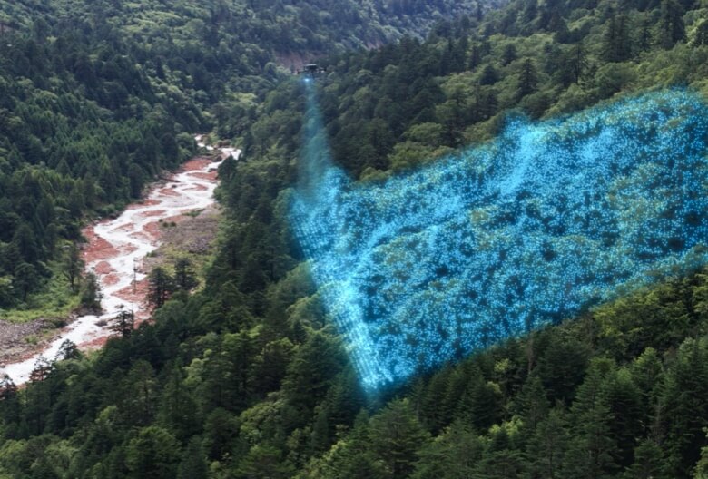
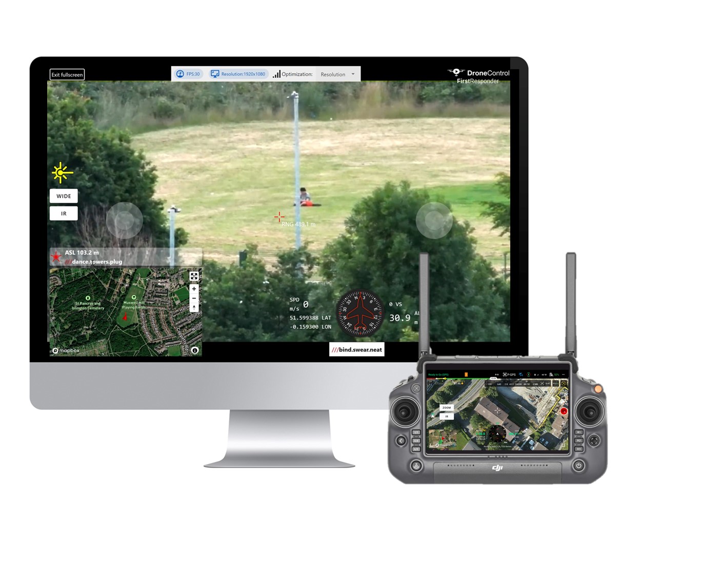
Iprosurv introduced drone technology to overcome these challenges and provide a highly effective solution for monitoring and evidential data collection. Drones were programmed to fly over extensive areas, capturing real-time, high-resolution imagery of sites where fly-tipping had been reported or was suspected.
The drones were capable of scanning large tracts of land quickly and accurately, providing coverage of areas that would have taken personnel days or even weeks to inspect manually.
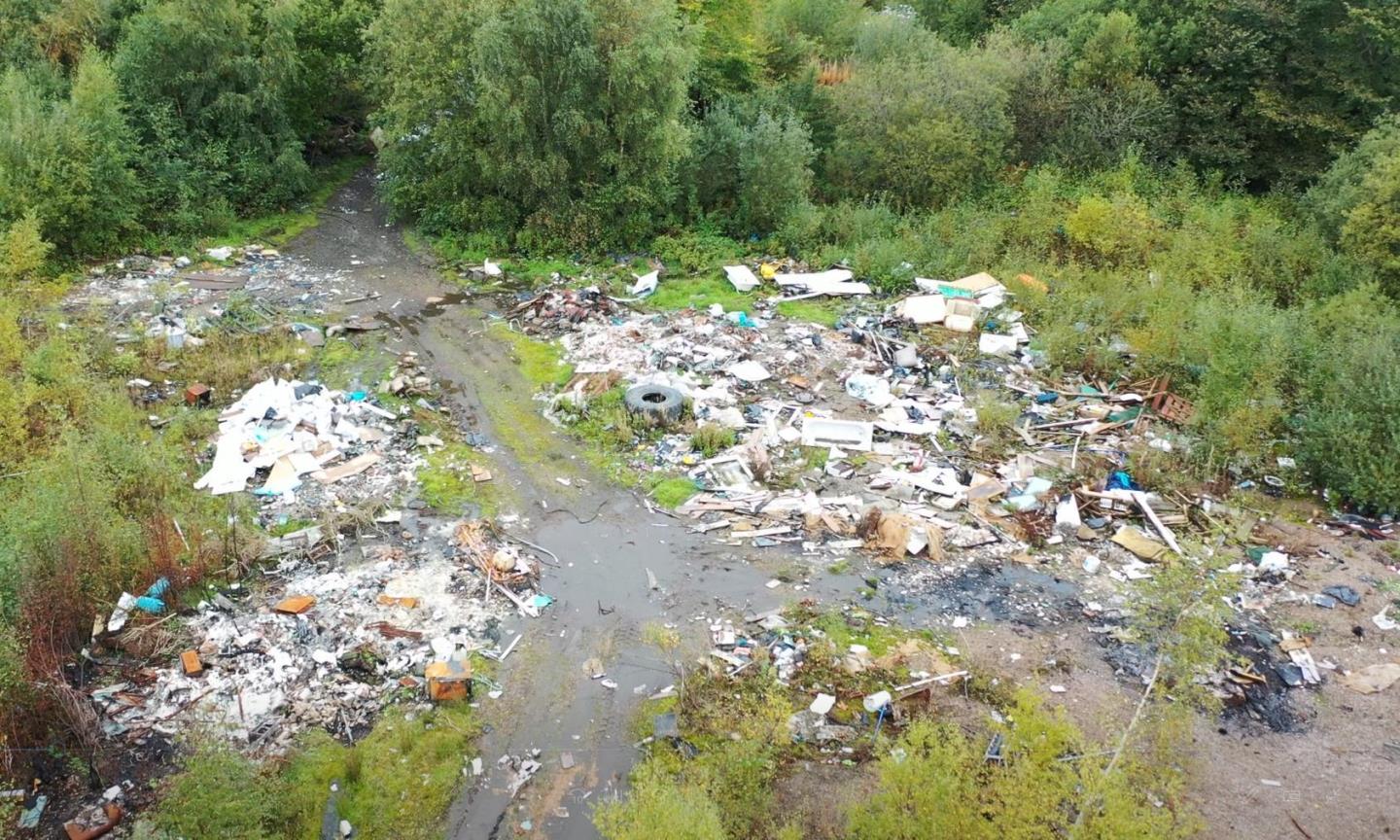
Equipped with advanced cameras and sensors, the drones captured detailed footage and images of the locations and waste materials, reducing the need for inspectors to physically visit hazardous sites.
Advantages of Drones in This Case Study
- Increased Efficiency: Drones significantly reduced the time required to inspect large areas and allowed multiple sites to be monitored in a single day.
- Improved Safety: The risk to personnel was eliminated, especially in dangerous areas containing harmful waste, such as asbestos. The drones could access hard-to-reach locations without endangering any humans.
- Real-Time Data: The ability to stream live footage and collect real-time data enabled immediate decisions on whether an area needed further investigation or legal action.
- Non-Confrontational Monitoring: By using drones, the possibility of encountering potentially aggressive individuals involved in illegal fly-tipping was completely avoided, making the process safer for enforcement authorities.
Software
The data collected by drones was fed into specialised software capable of processing aerial imagery and geospatial data. This software allowed for:
- Mapping: High-resolution maps of fly-tipping sites were created, with the ability to zoom in on specific areas to examine the extent and types of waste.
- Measurement: The software could automatically calculate the amount of waste in a given area by assessing its size and volume, providing key information needed for enforcement or prosecution.
- Historical Data Integration: By comparing new data with historical fly-tipping reports and previous drone flights, the client was able to assess patterns and determine whether fly-tipping activity was increasing, decreasing, or shifting geographically.
Data Processing
Once drone data was uploaded to the software platform, processing algorithms created detailed maps and 3D models of the affected areas. The real-time data allowed for rapid identification of new fly-tipping hotspots, while historical data analysis helped assess long-term trends.
This provided authorities with insights into the extent of the problem and potential patterns in illegal activity, which could be critical for planning enforcement strategies or implementing preventive measures.
The processed data could be easily shared with stakeholders, such as local authorities and environmental agencies, facilitating swift action and coordination between different organisations.