
CASE STUDY / AGRICULTURE
When a Seed Drill Fault Affected Crop Establishment
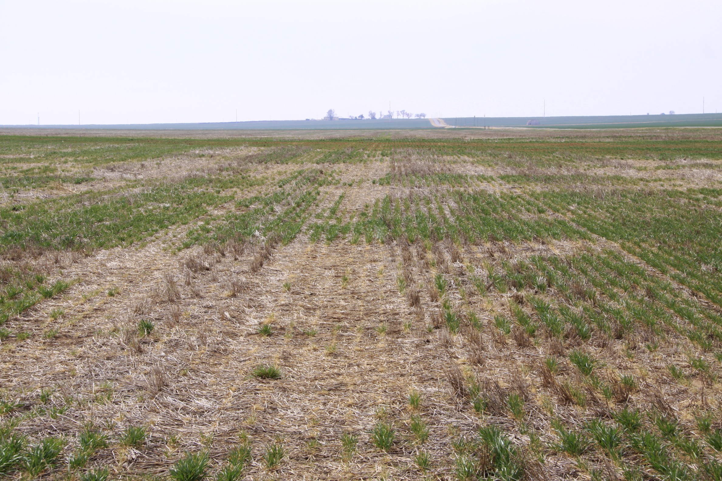
When uneven crop growth threatened a farmer's growing season, the priority was obtaining reliable evidence quickly. Iprosurv mapped the affected area to support assessment and timely decisions about potential re-ploughing and re-sowing.
2.14 acres of affected crop identified
THE PROJECT AT A GLANCE
01 / THE PROBLEM
The Challenge
Uneven crop establishment requiring prompt assessment of the affected area.
02 / THE SOLUTION
Our Approach
Aerial mapping to identify and measure areas of under-performing crop.
03 / THE FINDING
The Evidence
2.14 acres of affected crop identified for closer assessment.
04 / THE VALUE
Why Timing Matters
Timely evidence to support decisions while re-ploughing and re-sowing may still be possible.
UNDERSTANDING THE CHALLENGE
A Crop Problem With a Closing Window for Action
When uneven crop establishment became apparent, the immediate concern was not simply the appearance of the field. The farmer needed to understand how much of the crop was affected and what could still be done about it.
In agricultural operations, time can be critical. Depending on the crop, growing conditions and the point in the season, there may be an opportunity to re-plough and re-sow affected areas. But that opportunity can diminish as the growing season progresses.
The challenge was therefore to establish the extent of the problem quickly, provide measurable evidence for the farmer and insurer, and support an informed assessment while remedial options could still be considered.
DEVELOPING THE RIGHT SOLUTION
The Right Information. At the Right Time.
The farmer did not simply need more photographs of the field. The priority was understanding where crop establishment had been affected, measuring the extent of the problem and gathering useful evidence while there was still an opportunity to consider remedial action.
Aerial mapping provided a way to examine the wider field, identify visible patterns of uneven growth and establish the area requiring closer assessment.
The approach focused on producing measurable information that could support discussions between the farmer and insurer, rather than collecting imagery without a clear purpose.
01
See the Wider Picture
An aerial view helped reveal patterns of uneven crop establishment across the field, rather than relying solely on individual ground observations.
02
Measure the Problem
Mapping enabled affected areas to be identified and quantified, providing a clearer basis for reviewing the scale of the issue.
03
Support Timely Decisions
Gathering evidence promptly helped inform assessment while options such as re-ploughing and re-sowing could still be considered.
The objective was not the drone survey itself. It was giving the client information they could use to make an informed decision.
From Field Data to Measurable Evidence
Iprosurv followed a structured approach to capture, assess and map the affected crop, turning field observations into information that could support the farmer and insurer.
Capture the Field Data
Using a DJI Mavic 3 Multispectral, Iprosurv collected aerial imagery across the affected field to establish a consistent overview of crop establishment.
Review and Identify
The collected imagery was assessed to identify patterns of uneven crop growth and locate the areas requiring closer examination.
Measure and Present
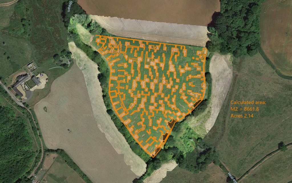
The affected areas were delineated and measured, producing mapped evidence to support the assessment and time-sensitive decisions about potential remedial action.
ACTUAL PROJECT EVIDENCE
A mapped overview identifying and measuring the affected areas of crop establishment.
2.14 acres
Identified area
THE PROJECT OUTCOME
A Clearer Picture. Time to Act.
The survey established the measured extent of the affected crop area, giving the farmer and insurer clear, mapped evidence to support their assessment.
With the scale of the problem quantified, discussions could move beyond identifying the damage towards considering the most appropriate next steps.
The real value was in the timing
of the information.
In agriculture, opportunities for remedial action can be limited by the growing season. Timely, measurable evidence can help inform decisions while options such as re-ploughing and re-sowing may still be available.
MEASURABLE PROJECT RESULT
2.14
Acres Identified
Affected crop establishment mapped and measured to support further assessment and informed decisions.
WHAT THE CLIENT RECEIVED
Evidence That Could Be Used, Not Just Viewed
The completed mapping brought together three important elements: a clear view of the field, the locations of uneven crop growth and a measurement of the affected area.
Together, these findings provided a common visual and measurable reference that the farmer and insurer could use when reviewing the problem.
THE EVIDENCE
A Field-Wide Overview
Aerial imagery showing the field in context, allowing the wider pattern of crop establishment to be examined.
Identified Areas of Concern
A mapped representation showing where inconsistent crop establishment had been identified.
Measured Extent
Calculated area measurements establishing the scale of the affected crop establishment for further assessment.
YOUR CHALLENGE. OUR EXPERIENCE.
Have a Challenge of Your Own?
You don't need to know which drone, sensor or survey method you require. You simply need to tell us what you're trying to achieve, what information you're missing or what problem you're facing.
Talk to Iprosurv
Explore More Case Studies
Start with your challenge. We'll explore the solution together.