
ENVIRONMENTAL ENFORCEMENT |
DRONE EVIDENCE COLLECTION
36 Sites. One Clearer Picture. How Drones Help Investigate Illegal Fly-Tipping
Illegal fly-tipping presents a persistent challenge for local authorities, damaging the environment, creating potential public health risks and placing considerable pressure on enforcement and waste management teams.
When a local authority needed to assess 36 separate locations, conventional inspections would require repeated site visits and consistent recording of the affected areas. The challenge was to collect reliable information quickly, without unnecessary exposure to potentially hazardous waste or difficult terrain.
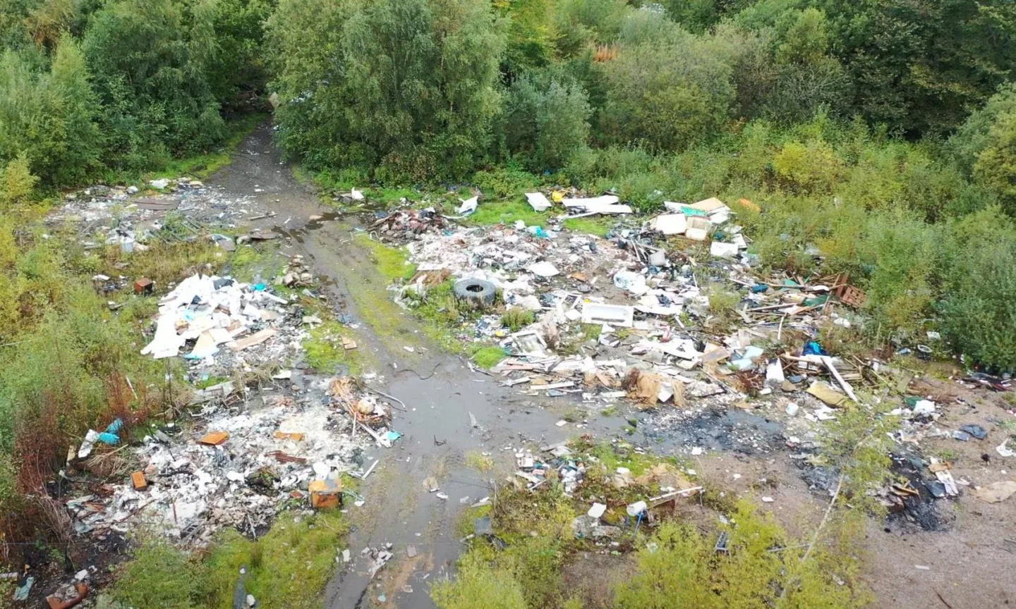
Using the DJI Matrice 4E, Iprosurv captured aerial imagery in approximately seven minutes per site. The resulting orthomosaic maps created measurable records to support ongoing monitoring, site assessment and enforcement planning.
36 locations surveyed,
mapping data processed
within 24 hours and
the complete service
delivered in under
five days, helping
the authority move
from scattered incidents
to a consistent
evidence base.
36 Locations. Consistent Evidence. A Smarter Approach to Enforcement.
THE CHALLENGE
36 Fly-Tipping Locations to Assess
A local authority needed a consistent picture of suspected illegal waste dumping across 36 separate sites. Potentially hazardous materials, difficult access and the need for repeatable records made conventional ground inspections challenging and resource-intensive.
OUR SOLUTION
Rapid Aerial Mapping with the Matrice 4E
Iprosurv deployed the DJI Matrice 4E to capture systematic, high-resolution aerial imagery, with approximately seven minutes of data capture per site. The imagery was processed into geographically referenced orthomosaic maps suitable for detailed site review.
THE FINDING
A Consistent Record of Affected Areas
The mapping provided a clear overhead record of each location, helping the authority examine waste deposits, access routes and areas requiring attention. The datasets established a reference for comparing future inspections and assessing changes in dumping activity.
THE VALUE
A Coordinated Response in Under Five Days
Mapping information was processed within 24 hours, with the overall programme completed in under five days. The evidence supported monitoring priorities, potential enforcement investigations and decisions about where fixed surveillance cameras could provide additional value.
03 | UNDERSTANDING THE CHALLENGE
36 Locations. One Growing Environmental and Enforcement Challenge.
Illegal fly-tipping is more than an unsightly problem. Dumped waste can contaminate land, threaten wildlife, obstruct access routes and create potential health and safety risks. For local authorities, responding to incidents across multiple locations places considerable pressure on enforcement and environmental teams.
The scale of the task was the first challenge. With 36 separate locations requiring assessment, the authority needed a consistent way to document the affected areas. Conventional ground inspections could involve repeated visits, difficult access and considerable time spent recording each site.
Personnel safety was another important consideration. Fly-tipped material can contain sharp objects, hazardous substances and unstable waste piles. Surveying from ground level may require personnel to approach potentially dangerous materials simply to establish the extent of a dumping incident.
The authority also needed reliable, repeatable evidence. Individual photographs can show the presence of waste, but may not reveal its full distribution, relationship to access points or wider environmental impact. Consistent aerial mapping could provide a clearer geographic record of each location.
A further challenge was future monitoring. Where fly-tipping incidents recur, local authorities need to understand whether waste deposits are increasing, moving or returning after clearance. Comparable survey records could also help identify locations where fixed surveillance cameras might provide value.
Iprosurv needed to deliver a fast, consistent and geographically referenced assessment across all 36 sites. The information had to support practical decisions about site management, monitoring priorities and potential enforcement investigations, without unnecessary exposure to hazardous waste.
From 36 Separate Locations to One Consistent Evidence Base
Investigating illegal fly-tipping across 36 separate locations required more than simply capturing photographs of discarded waste. The local authority needed a consistent method of recording each site so the information could be reviewed, compared and used to support future decisions.
Iprosurv developed a coordinated aerial mapping approach using the DJI Matrice 4E. Its high-resolution imaging and automated mapping capabilities enabled detailed site information to be captured efficiently while reducing the need for personnel to approach potentially hazardous waste deposits.
Each location was surveyed using overlapping aerial imagery, suitable for processing into geographically referenced orthomosaic maps. With approximately seven minutes of aerial data capture per site, the approach provided an efficient way to document multiple locations within a coordinated inspection programme.
The resulting maps provided more than an individual aerial view. They placed visible waste deposits within their surrounding environment, helping the authority understand the relationship between dumping areas, access routes and nearby land.
Importantly, the digital records could be used as a reference for subsequent inspections. This would enable the authority to examine changes at individual locations, review the effectiveness of clearance activities and identify areas where additional monitoring might be appropriate.
01 / RAPID DATA CAPTURE
Efficient Aerial Surveys Across 36 Locations
Deploy the DJI Matrice 4E to capture consistent, high-resolution aerial imagery at each identified location. With approximately seven minutes of data capture per site, Iprosurv could document visible waste deposits and surrounding conditions efficiently, while reducing unnecessary close contact with potentially hazardous materials and difficult terrain.
02 / DIGITAL MAPPING
Turning Site Images into Geographic Evidence
Process the overlapping aerial photographs into detailed orthomosaic maps, creating a consistent geographic record of each location. These outputs made it easier to examine the extent and distribution of visible waste, understand site access arrangements and identify areas requiring further assessment or clearance planning.
03 / MONITORING & ENFORCEMENT
Repeatable Evidence for Better-Informed Decisions
Establish a digital reference for subsequent site inspections and environmental monitoring. Comparable mapping can help identify new dumping activity, document changes after clearance and support decisions about further investigation. The information could also help determine locations where fixed surveillance cameras might be most effective.
The value of the solution was not simply flying a drone over 36 locations. It was establishing a consistent, geographically referenced record that the local authority could use to assess environmental damage, prioritise monitoring and support potential enforcement investigations. By combining rapid aerial data capture with detailed digital mapping, Iprosurv helped turn separate fly-tipping incidents into a more coordinated approach to environmental management.
05 | OPERATIONAL DELIVERY
36 Locations. Seven Minutes per Site. One Coordinated Survey.
Iprosurv delivered a coordinated drone mapping programme across 36 locations, collecting consistent visual information to help the local authority assess fly-tipping activity and establish a digital reference for future monitoring.
01
Site Planning and Safe Drone Deployment
Each location was assessed for suitable flight operations, considering access arrangements, surrounding land use, potential hazards and the areas requiring aerial coverage.
Particular attention was given to reducing unnecessary proximity to waste deposits, potentially hazardous materials and difficult terrain while collecting the required visual information.
02
Rapid Aerial Mapping Across 36 Sites
Using the DJI Matrice 4E, Iprosurv captured high-resolution, overlapping aerial imagery of each location, with approximately seven minutes of data capture per site.
This systematic approach documented visible waste deposits, affected land, access routes and surrounding features, creating consistent information suitable for geographic mapping.
03
Orthomosaic Processing and Data Delivery
The aerial photographs were processed into geographically referenced orthomosaic maps, giving the authority a detailed overhead record of the surveyed locations.
Mapping information was processed within 24 hours, with the complete survey programme delivered in under five days.
The resulting information supported site assessment, monitoring priorities and consideration of where further investigation or fixed surveillance might be appropriate.
36 Sites Documented. Better Evidence. More Informed Environmental Decisions.
The project demonstrated how professional drone mapping can help local authorities respond to illegal fly-tipping across multiple locations without relying solely on conventional ground inspections and individual photographs.
Using the DJI Matrice 4E, Iprosurv captured aerial imagery across 36 separate sites, with approximately seven minutes of data capture per location. Mapping information was processed within 24 hours, and the complete programme was delivered in under five days.
The resulting orthomosaic maps gave the authority a consistent geographic record of the surveyed locations, supporting assessment of visible waste deposits, future monitoring and more targeted environmental management.
01 / RAPID SITE ASSESSMENT
36 Locations Surveyed Efficiently
Approximately seven minutes of aerial data capture per site enabled Iprosurv to document the identified locations through a coordinated survey programme. This demonstrated an efficient approach to collecting visual information across multiple fly-tipping incidents, reducing the time required for on-site data capture.
02 / SAFER DATA COLLECTION
Reducing Unnecessary Exposure to Waste
Aerial inspection enabled the condition and extent of affected areas to be recorded without requiring survey personnel to approach every waste deposit. This reduced the need for close contact with potentially hazardous materials, unstable waste piles and difficult terrain during the initial assessment.
03 / REPEATABLE DIGITAL EVIDENCE
A Consistent Record for Future Monitoring
Geographically referenced orthomosaic maps provided a clear visual record of each surveyed location. The information established a baseline that could be compared with subsequent surveys to identify new waste deposits, monitor changes and document the condition of areas following clearance activities.
04 / TARGETED ENFORCEMENT
Better Information for Resource Planning
The mapping helped place individual incidents within their wider geographic context. This information could support decisions about further investigation, environmental management priorities and where fixed surveillance cameras might provide additional value in monitoring suspected repeat dumping locations.
36 Sites.
Under 5 Days.
Under 5 Days.
The most significant outcome was not simply the speed of the drone survey. It was the creation of a consistent, geographically referenced evidence base across 36 separate locations. With mapping processed within 24 hours, the local authority could review affected areas, establish a reference for future monitoring and make better-informed decisions about environmental management, surveillance priorities and potential enforcement investigations.
07 | WHAT THE CLIENT RECEIVED
From Individual Fly-Tipping Incidents to Actionable Environmental Intelligence
The local authority needed more than a collection of photographs showing illegally dumped waste. It needed a consistent understanding of the affected locations, supported by accurate geographic information that could inform future decisions.
Iprosurv surveyed 36 separate locations, producing detailed orthomosaic mapping from high-resolution drone imagery. This provided a geographically referenced visual record of the surveyed areas, helping the authority assess visible waste deposits and their surrounding environment.
The maps offered important context. Rather than examining isolated photographs, officers could review the distribution of waste, nearby access routes and the relationship between affected areas and surrounding land.
The information also established a useful reference for future inspections. Repeat aerial surveys could help the authority identify new deposits, compare conditions following clearance and monitor locations where fly-tipping may recur.
The survey records could also support enforcement planning. By understanding the layout and accessibility of individual sites, the authority could make more informed decisions about where additional investigation, targeted inspections or fixed surveillance cameras might be appropriate.
With mapping processed within 24 hours and the overall programme delivered in under five days, Iprosurv demonstrated how drone technology can turn widespread environmental incidents into structured, useful geographic information.
The real value of this project was not simply surveying 36 locations in under five days. It was giving the local authority a consistent, geographically referenced view of the problem. By transforming aerial imagery into detailed digital mapping, Iprosurv provided information that could support environmental monitoring, better-targeted resource allocation and more informed enforcement planning. The result was a stronger foundation for understanding and responding to illegal fly-tipping.
You Cannot Tackle What You Cannot Properly See.
Illegal fly-tipping continues to place pressure on local authorities, landowners and environmental enforcement teams. From isolated rural locations to industrial land and urban areas, discarded waste can damage the environment, create health and safety risks and demand considerable resources to investigate and remove.
But how effectively can you respond without a clear understanding of where the problem exists and how it is changing?
Iprosurv demonstrated what is possible when professional drone surveying is combined with detailed geographic data processing. Across 36 separate fly-tipping locations, our team captured high-resolution aerial imagery in approximately seven minutes per site, with the overall programme delivered in under five days.
The resulting orthomosaic maps provided the local authority with a consistent visual record of affected areas, supporting site assessment, future monitoring and decisions about environmental management and potential enforcement investigations.
Drone technology cannot stop illegal dumping on its own. However, it can help authorities understand the scale of a problem, improve the consistency of their evidence and make more informed decisions about where to focus resources.
Whether you are dealing with persistent fly-tipping, monitoring environmental damage or managing large areas of land, Iprosurv can help you explore how drone mapping and digital data could support your operations.