
STORM RECOVERY |
FORESTRY MAPPING & ASSESSMENT
When Storms Devastate Forests: How Drones Help Turn Destruction into Recovery
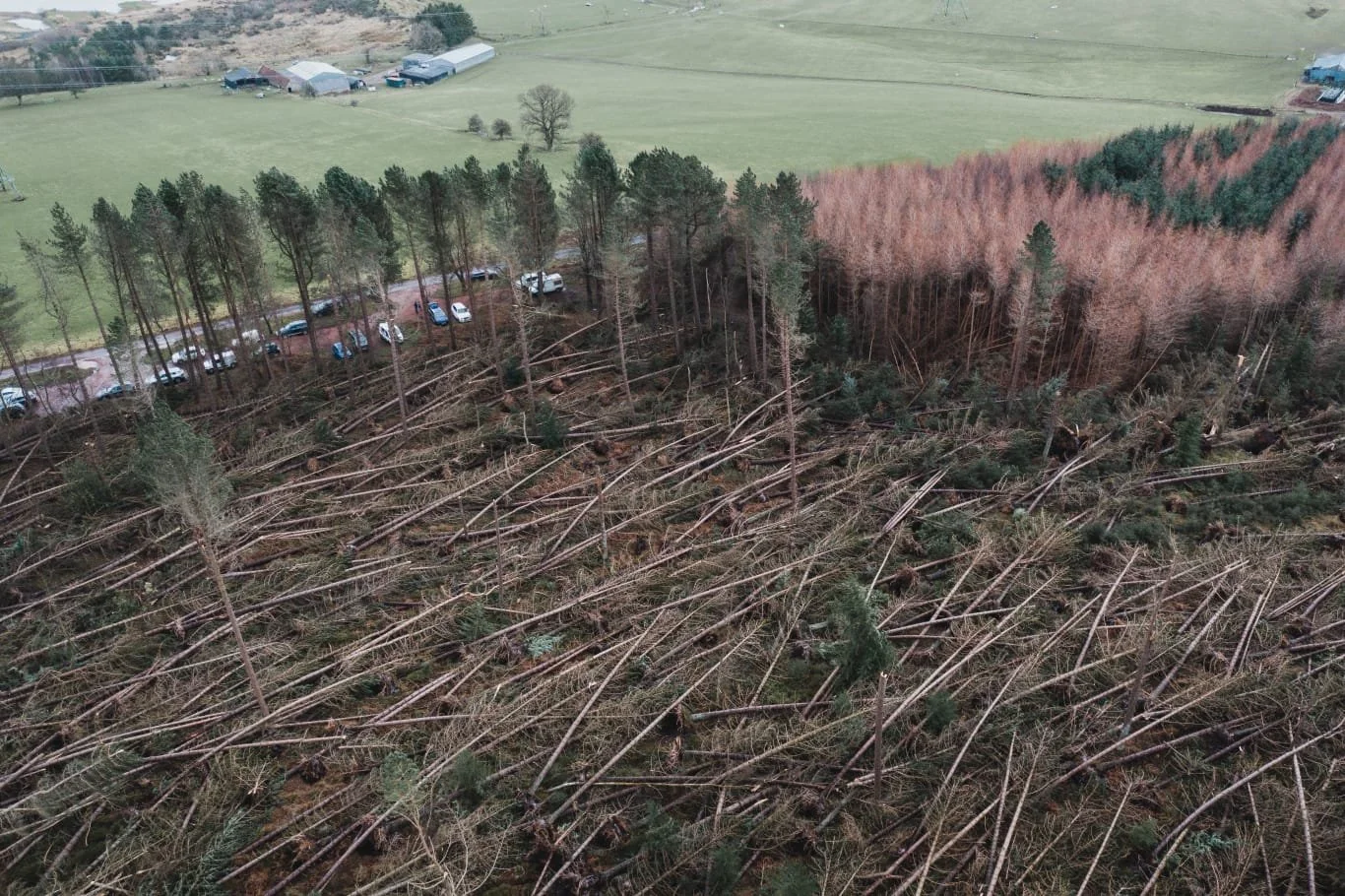
When Storm Arwen struck in November 2021, extensive areas of Scottish forestry suffered catastrophic windblow damage. Commercial pine plantations were left with uprooted, snapped and dangerously unstable trees, creating significant safety and financial challenges for woodland owners.
The priority was to establish the extent of the damage, identify recoverable timber and produce reliable mapped evidence to support additional felling permissions where required. Dangerous trees also threatened woodland access routes and public paths, making rapid assessment essential for safe recovery.
Iprosurv used drone mapping
to create detailed aerial
imagery and digital surface
information, helping identify
damaged timber, support
felling applications and
inform safer, faster
woodland recovery planning.
Understanding the Damage. Accelerating the Recovery.
THE CHALLENGE
Devastated Woodland and Dangerous Access
Storm Arwen left extensive areas of commercial pine forestry damaged by windblow. Uprooted and partially fallen trees created serious hazards, including near woodland routes and public rights of way. Rapid evidence was needed to assess damage and support recovery decisions.
OUR SOLUTION
250 Hectares Surveyed by Drone
Iprosurv deployed a specialist drone team to survey approximately 250 hectares in eight hours. High-resolution aerial imagery was processed into orthomosaic maps and digital terrain and surface information, enabling large areas to be assessed without requiring personnel to enter unstable woodland.
THE FINDING
A Clear Picture of the Damage
Detailed aerial mapping helped identify affected forestry compartments, fallen timber, obstructed access routes and areas requiring clearance. The digital outputs provided mapped evidence to support further assessment, felling applications and the planning of safe recovery operations.
THE VALUE
Recovery Planning Within 72 Hours
Processed survey data was delivered within 72 hours, helping forestry managers make faster decisions about damaged timber, additional felling requirements, contractor access and restoration. Earlier information supported both the financial recovery of timber and the management of public safety risks.
03 | UNDERSTANDING THE CHALLENGE
Dangerous Woodland. Urgent Decisions. Recovery That Could Not Wait.
Storm Arwen left large areas of commercial pine forestry severely damaged. Trees that had taken decades to grow were uprooted, snapped or left partially fallen, creating a complex recovery challenge for woodland owners and forestry managers.
The immediate problem was access and safety. Windblown trees can remain under considerable tension, with unstable root plates, suspended trunks and partially supported canopies presenting serious hazards. Access tracks and public rights of way could also be obstructed by fallen timber.
Entering these areas to conduct conventional ground surveys was potentially dangerous. Yet forestry managers needed to identify where the damage was concentrated, which compartments were affected and how clearance operations could be organised without exposing personnel to unnecessary risks.
There was also a significant financial pressure. Commercial timber represents years of investment. Delays in assessing and recovering damaged stock could affect its recoverable value, increase harvesting costs and complicate arrangements with contractors and timber processors.
The exceptional scale of the windblow also created challenges for normal forestry management plans. Damage extended into areas that had not necessarily been scheduled for felling. Where existing approvals did not cover the required operations, additional permission or changes to approved plans could be necessary.
Forestry managers needed mapped evidence, not just an estimate of the damage. Clear information identifying affected compartments, damaged tree cover and proposed clearance areas would support discussions with forestry authorities and help prioritise the next stages of recovery.
The challenge for Iprosurv was therefore to survey extensive, hazardous woodland quickly and deliver sufficiently detailed aerial information to support safe access planning, timber recovery, felling applications and future restocking.
From Dangerous Woodland to Actionable Digital Evidence
The traditional approach to understanding storm damage would involve surveyors entering affected woodland, identifying fallen timber and attempting to map the scale of the destruction from ground level. Following Storm Arwen, this presented a significant challenge.
Large areas contained unstable trees, exposed root plates, suspended timber and obstructed access routes. Even reaching some of the damaged compartments could expose personnel to unnecessary risk.
Iprosurv developed a drone-based mapping approach that would capture the required information from above, without first requiring surveyors to walk through the most hazardous areas.
Using the DJI Mavic 3E, high-resolution aerial photographs could be collected systematically across the affected woodland. Photogrammetric processing then transformed the overlapping imagery into detailed orthomosaic mapping and digital surface models.
These digital products allowed forestry managers to examine patterns of windblow, identify concentrations of damaged trees and assess the spatial extent of affected compartments. Surface models added a further dimension, helping distinguish changes in woodland structure and identify areas requiring closer investigation.
Crucially, the information was geographically referenced. This meant that damaged areas could be located, measured and presented clearly to support clearance planning, timber recovery decisions and any necessary discussions about additional felling permissions.
01 / SAFE DATA CAPTURE
Surveying Damaged Forestry from Above
Use the DJI Mavic 3E to collect overlapping, high-resolution imagery across extensive areas of storm-damaged woodland. By operating from suitable safe locations, the drone could document windblown trees and inaccessible compartments while reducing the need for surveyors to enter unstable forestry during the initial assessment.
02 / DIGITAL MODELLING
Turning Aerial Images into Measurable Information
Process the captured photographs into detailed orthomosaic maps and digital surface models. These outputs provide a wider view of woodland damage, helping forestry managers locate affected compartments, assess concentrations of windblown timber and examine changes in the visible forest canopy and surface structure.
03 / RECOVERY EVIDENCE
Supporting Felling Decisions and Timber Recovery
Convert the mapped survey information into evidence that woodland managers could use to assess clearance priorities, plan contractor access and identify areas requiring additional felling permissions. The same information could support decisions about recovering commercially valuable timber and preparing affected areas for future restocking.
The real value was not simply flying a drone over damaged trees. It was transforming hazardous, difficult-to-access woodland into a clear digital record that forestry managers could interpret, measure and act upon. By combining aerial imagery with digital surface modelling, Iprosurv helped provide the evidence needed to prioritise public safety, support felling applications, plan timber recovery and move towards woodland restoration.
05 | OPERATIONAL DELIVERY
From Storm-Damaged Woodland to Digital Evidence in 72 Hours
Following Storm Arwen, Iprosurv deployed a specialist drone team to capture the scale of the destruction without exposing survey personnel to the considerable hazards associated with unstable windblown trees.
01
Safe Deployment and Survey Planning
A three-person drone team planned the aerial survey around the affected woodland, identifying suitable operating locations and the areas requiring coverage.
The priority was to collect consistent, high-resolution imagery while minimising the requirement for personnel to enter forestry containing partially fallen trees, unstable root plates and obstructed access routes.
02
Extensive Aerial Data Collection
Using the DJI Mavic 3E, the team conducted systematic aerial mapping across approximately 250 hectares of storm-damaged woodland.
The survey was completed in approximately eight hours, capturing overlapping imagery suitable for photogrammetric processing.
This provided a detailed visual record of windblown tree cover, damaged compartments and access routes, without requiring a conventional ground survey of the affected areas.
03
Digital Processing and Rapid Delivery
The aerial imagery was processed into high-resolution orthomosaic mapping, digital terrain information and a supporting three-dimensional representation of the site.
GIS-compatible files, including orthomosaic imagery in TIFF format, enabled the client to review the affected woodland within its preferred QGIS environment.
The processed information was delivered within 72 hours, providing a basis for prioritising clearance, considering additional felling permissions and planning timber recovery operations.
Safer Decisions. Faster Evidence. A Clearer Path to Forestry Recovery.
Following Storm Arwen, woodland managers faced the difficult task of assessing widespread destruction while protecting personnel and the public from dangerously unstable trees. The financial implications of delayed timber recovery added further urgency.
Iprosurv's drone survey transformed extensive areas of damaged woodland into detailed digital mapping information. With processed data delivered within 72 hours, forestry managers had geographical evidence to support decisions about clearance priorities, timber recovery and future woodland restoration.
The project demonstrated how aerial mapping can provide valuable information at a critical point, when decisions need to be made but conventional ground access is difficult or unsafe.
01 / PUBLIC & WORKER SAFETY
Assessing Dangerous Woodland from Above
Drone mapping enabled an initial assessment of extensive windblown forestry without requiring surveyors to enter the most hazardous areas. This reduced exposure to unstable root plates, suspended timber and partially fallen trees while helping identify affected access routes and locations needing further safety review.
02 / RAPID DIGITAL EVIDENCE
Mapping Information Within 72 Hours
High-resolution aerial imagery and processed mapping outputs were made available within 72 hours, providing a detailed overview of the affected woodland. The digital information enabled damaged compartments to be located and examined, supporting faster assessment and more informed recovery planning.
03 / COMMERCIAL TIMBER RECOVERY
Supporting Time-Critical Timber Decisions
Mapped evidence helped forestry managers understand where storm-damaged timber was concentrated and which areas required attention. This information could support contractor planning, timber recovery priorities and additional felling applications where necessary, reducing uncertainty at a commercially sensitive time.
04 / LONG-TERM RESTORATION
A Digital Foundation for Replanting
Orthomosaic mapping and digital surface information provided a geographic reference for future work. Forestry managers could use the survey outputs to inform clearance strategies, identify areas requiring further assessment and support the planning of restocking and longer-term woodland restoration.
72 Hours.
A Clearer Way Forward.
A Clearer Way Forward.
The most important result was not simply how quickly the drone survey was completed. It was the ability to provide detailed, measurable information when woodland managers faced urgent decisions about safety, felling permissions and commercially valuable timber. By turning widespread storm damage into usable digital evidence, Iprosurv supported a more informed and coordinated approach to clearance, timber recovery and woodland restoration.
07 | WHAT THE CLIENT RECEIVED
More Than Aerial Images. The Evidence Needed to Plan Recovery.
Following the devastation caused by Storm Arwen, Iprosurv provided the forestry management team with detailed aerial mapping and digital information covering the affected woodland.
Rather than relying solely on ground-level observations or estimates of the damage, the client could examine the site through a geographically referenced record of the storm's impact.
High-resolution orthomosaic mapping provided an overhead view of the forest, making it easier to identify the distribution of windblown trees, affected compartments and obstructed access routes.
Digital surface models added another dimension to the assessment, helping distinguish changes in the visible forest canopy and concentrations of damaged timber.
The processed mapping information was delivered within 72 hours, providing evidence at a time when delays could affect both public safety and the commercial recovery of valuable timber.
The digital outputs could also be reviewed within geographic information systems such as QGIS, allowing woodland managers to examine specific locations, plan clearance activities and identify areas requiring further ground investigation.
Where exceptional windblow required additional felling approval, the geographically referenced evidence could help demonstrate the extent and location of affected woodland to the relevant forestry authority.
Beyond the immediate response, the survey provided a digital reference for subsequent clearance, restocking and woodland restoration planning.
The client received more than a record of the devastation left by Storm Arwen. Iprosurv provided geographically referenced digital evidence that could help identify damaged timber, support safe clearance planning, inform felling applications and guide woodland recovery. By making large areas of dangerous forestry visible and measurable, the survey supported more informed decisions at a time when safety, speed and commercial value all mattered.
When Disaster Strikes, Can You Afford to Wait for the Information You Need?
Storm Arwen demonstrated how quickly a valuable forestry asset can become a serious operational, financial and public safety challenge.
Dangerous windblown trees, inaccessible woodland, obstructed public routes and the urgent need to recover damaged timber created a situation where reliable information was essential.
Iprosurv used professional drone mapping technology to capture extensive areas of damaged forestry and deliver detailed digital information within 72 hours.
The resulting orthomosaic maps and digital surface models helped make the extent of the damage visible, measurable and easier to assess.
For woodland owners, forestry managers and land management organisations, this information can support the identification of dangerous areas, prioritisation of timber clearance, preparation of additional felling applications and future restoration planning.
But the applications extend well beyond storm recovery. Drone mapping can support routine forestry management, woodland condition assessments, environmental monitoring, access planning and the development of accurate digital records across large landholdings.
You cannot always prevent the storm. But you can improve how quickly you understand the damage and plan what happens next.