Watching Confidence Take Flight
How One Student Grew from Beginner Mapper to Producing a Great 1st 3D Model
Every training provider hopes to see their learners progress beyond the classroom, applying their new skills with confidence and purpose. At Iprosurv, we are privileged to witness these transformations every day. But every now and then, a learner’s journey stands out, reminding us exactly why we are so passionate about delivering high-quality, industry-focused drone training.
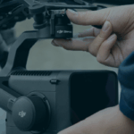
This is the story of one operator who joined our two-day Basic Mapping Course with a DJI Mavic Mini 3 Pro and a desire to do more with their drone. What followed was a remarkable leap in understanding, confidence, and capability.
Day One
Discovering the Power of Accurate Data Capture
When Liam arrived, he was like many drone operators we met: skilled at flying but unsure how to translate that into reliable mapping data. They were curious, open-minded, and ready to learn. As trainers, that combination is invaluable.
We began by stripping mapping back to its foundations-no complex software. No automation. Just pure technique.
We explored:
- Predictable, controlled flight patterns
- Why overlap and sidelap matter
- Image quality and consistency
- Altitude management
- The principles that make photogrammetry work
As the day progressed, we watched the mindset shift. Flying was no longer about motion; it became about collecting purposeful, structured data. You could see their confidence growing with each exercise.
Building Understanding Through a Small-Scale Dataset
To help students grasp the foundations of 3D data capture, we begin with something intentionally simple: a skip. At first glance, it may appear an unlikely subject, yet its scale and structure make it an ideal training tool. By working with a small, contained object, learners can slow the process down and see how each image contributes to the final 3D model.
During this exercise, students collect the dataset manually, without the assistance of automated software or pre-programmed flight paths. This encourages them to think critically about positioning, angle, and timing. Every photograph becomes a deliberate choice rather than an automated output.
We guide them through capturing a balanced mix of Nadir, Oblique, and Tie-in images, demonstrating how each one serves a different role within the model reconstruction. The skip’s manageable size allows students to visualise image overlap in real time, understanding how each photograph must intersect with the next to form a coherent, high-definition model.
This practical, hands-on approach gives learners a deeper appreciation of data integrity. Before they step into more complex environments, they gain the confidence to understand why overlap matters, how consistency drives quality, and how thoughtful image capture underpins every successful 3D model.
Day Two
Moving from Theory to Practical Application
The second day brought everything together. We guided them through planning a mapping mission, executing a structured capture, and understanding how data translates into a digital model.
Their flight lines became more deliberate. Their positioning grew more precise. They began anticipating the software’s needs before taking each image. It was clear that the fundamentals were clicking into place.
By the end of the course, they were no longer thinking like a recreational pilot. They were thinking like a mapper.
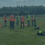
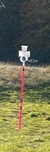
Practising Precision in the On-Site Flying Area
Alongside structured data-capture exercises, students also benefit from dedicated time in our on-site practical flying area. This controlled environment is purpose-built to develop smooth, confident manoeuvring and the positional accuracy required for high-quality 3D modelling work.
Using exercise poles set out in defined patterns, learners practise flying deliberate routes that mirror the movements used in real data-gathering missions. These drills focus on steady transitions, maintaining consistent altitude, and positioning the aircraft with intention rather than instinct. It is here that students learn how every subtle input affects the stability of the drone, the sharpness of the imagery, and ultimately the reliability of the dataset.
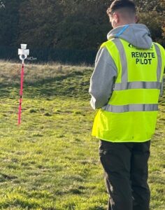
Having an on-site flying area means students gain maximum instructor-led practice, with real-time coaching and immediate feedback. They are encouraged to repeat sequences, refine techniques, and gradually build their flying hours in a safe, structured space. By the time they move on to more complex environments, they do so with a stronger command of the aircraft and a clearer understanding of how controlled flight underpins effective data collection.
Taking It Home
Putting New Skills Into Practice
Once the course ended, their journey continued. They returned home, eager to test their new knowledge in a real environment. With the Mini 3 Pro, they planned their first independent mapping mission using the manual techniques we had taught them.
A short time later, an email arrived. Attached was their dataset.
Immediately, we could see their progress. Every image had a purpose. Their patterns were consistent. Their overlap was strong. This was not the work of someone guessing their way through a flight. This was a developing professional, applying technique with growing assurance.
The First 3D Model
Seeing The Achievement Come to Life
When we processed the dataset, the model rose on screen: a clean, detailed, well-structured 3D reconstruction created entirely from the data they had captured on their own.
For a first attempt, it was exceptional.
You could see the thought behind every pass of the drone. The precision in the alignment. The care in consistent exposure and angle. All of it reflected a learner who had absorbed their training and applied it with real skill.
Even through email, their excitement was clear. And for us, it was a proud moment. Watching a learner’s first model appear, knowing how far they have come in such a short time, is one of the most rewarding experiences we have as trainers.
Beyond the Basics
From Manual Mastery to Automated Progression
With a solid grounding in manual data capture, stepping into automated mapping missions became their natural next step. And because they understood the fundamentals, automation became a tool to amplify their ability rather than compensate for gaps in knowledge.
This is the progression we aim for with every learner.
Begin with technique. Build understanding. Then enhance it with technology.
Why Their Journey Matters
And What It Means for New Drone Operators
This operator’s growth is a perfect example of what the right training can do. They arrived with enthusiasm. They left with knowledge. And they continued with confidence.
Their 3D model was not just a product of software. It was a reflection of learning, commitment, and the understanding that mapping is far more than flying a drone. It is intention, consistency, and precision.
At Iprosurv, we are proud to support operators as they step into this world. Seeing their success is a reminder that high-quality training is not just about passing a course. It is about unlocking capability.
Ready to Start Your Mapping Journey?
If you want to build real mapping skills, learn how to create accurate 3D models, and gain confidence in both manual and automated missions, Iprosurv will guide you every step of the way.
You have the potential.
We will help you turn it into performance.