DJI Zenmuse L3: High-Accuracy Long-Range LiDAR Now Available at Iprosurv
DJI Zenmuse L3: High-Accuracy Long-Range LiDAR Now Available at Iprosurv
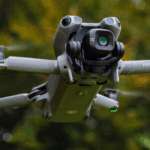
We’re excited to announce that the DJI Zenmuse L3 is now available to pre-order at Iprosurv, bringing a new level of precision and efficiency to aerial mapping and surveying. This groundbreaking LiDAR system combines long-range detection, dual 100MP RGB cameras, and advanced software integration, making it a game-changer for enterprise geospatial operations.
Long-Range, High-Accuracy LiDAR
The Zenmuse L3 features a 1535nm LiDAR system capable of detecting objects up to 950 meters away, even with just 10% reflectivity. Its proprietary high-accuracy system delivers vertical accuracy improvements of 3–10 cm depending on altitude, while a laser beam divergence of 0.25 mrad allows it to detect smaller objects like power lines or branches with remarkable detail.
Dual 100MP RGB Mapping Cameras
Equipped with dual 100MP RGB sensors and a mechanical shutter, the Zenmuse L3 captures ultra-high-resolution imagery with a horizontal field of view of 107°. At a flight altitude of 300m, it achieves a ground sample distance (GSD) of just 3cm, allowing for faster, more accurate mapping.
Superior Efficiency and Penetration Capability
With a laser pulse rate of 2 million points per second and support for up to 16 returns, the Zenmuse L3 excels in penetrating dense forests or complex urban environments. Mounted on a DJI Matrice 400, a single flight can cover up to 10 km², enabling up to 100 km² per day. Both LiDAR and RGB data can be captured simultaneously to generate multiple mapping deliverables, including digital orthophoto maps (DOM) and digital elevation models (DEM).
Seamless DJI Ecosystem Integration
Zenmuse L3 integrates with DJI’s full enterprise ecosystem, including the D-RTK 3 Multifunctional Station, DJI Pilot 2, DJI Terra, DJI Modify, and DJI FlightHub 2. This end-to-end workflow simplifies data acquisition, processing, and application, making high-precision aerial surveying more accessible and efficient than ever.
Applications Across Industries
The Zenmuse L3 is ideal for a wide range of applications, including:
-
Topographic surveys
-
Forestry and vegetation mapping
-
Energy infrastructure inspection
-
Emergency response
-
Historical conservation projects
Order the Zenmuse L3 Today
The DJI Zenmuse L3 is available now through Iprosurv, giving your enterprise access to cutting-edge LiDAR technology and advanced aerial mapping capabilities.
Contact us on 0114 4055 007 or email sales@iprosurv.com to learn more and order your Zenmuse L3.